Log in
All resources
Create a design
299 Free Images of Menai Strait
bibliothèque nationale de france
17th-century maps of the strait of magellan
oil on canvas
louis choris
map of the bosphorus strait by guillaume sanson (1665)
golden gate (strait)
voyage pittoresque autour du monde (1822) by louis choris
davis strait
old maps of the strait of gibraltar
map of the strait of kerch by guillaume sanson
maps of the magellan straits by lambert cornelis
context files from gallica
clinton hart merriam
barry glacier
gartenlaube (1891)
carl saltzmann
prints by thomas ashburton picken in the welsh landscape collection
1849 lithographs of wales
catalogue of the birds in the british museum (1898)
leucocarbo stewarti
gartenlaube (1896)
alexander kircher
marine paintings by holger lübbers
strait of messina
aboriginal australians in art
charles eaton (ship, 1833)
the outing magazine, 1909
strait of messina
1680s maps of north america
hugo allardt
1923 stamps of the united states
william alexander coulter
clinton hart merriam
bering sea
the bottom of the sea (1870)
strait of gibraltar
maps of strait of messina
jean-pierre houël
description
historical
map of the bosphorus strait by guillaume sanson (1665)
bibliothèque nationale de france
map of the bosphorus strait by guillaume sanson (1665)
bibliothèque nationale de france
map of the strait of kerch by guillaume sanson
bibliothèque nationale de france
map of the bosphorus strait by guillaume sanson (1665)
bibliothèque nationale de france
map of the bosphorus strait by guillaume sanson (1665)
bibliothèque nationale de france
map of the bosphorus strait by guillaume sanson (1665)
bibliothèque nationale de france
map of the strait of kerch by guillaume sanson
bibliothèque nationale de france
map of the strait of kerch by guillaume sanson
bibliothèque nationale de france
map of the strait of kerch by guillaume sanson
bibliothèque nationale de france
map of the bosphorus strait by guillaume sanson (1665)
bibliothèque nationale de france
map of the strait of kerch by guillaume sanson
bibliothèque nationale de france
map of the bosphorus strait by guillaume sanson (1665)
bibliothèque nationale de france
maps of the strait of dover
cartes de franz schrader
landscape paintings of new zealand
nicholas chevalier
vernacular architecture of australia
aboriginal australians in art
voyage pittoresque autour du monde (1822) by louis choris
bering strait
presidio of san francisco before 1995
adam cuerden's restorations
australasian sketcher
1836 births
oil marine paintings by jens erik carl rasmussen
19th-century sailing ships in paintings
john ward (painter)
history of whaling
voyage pittoresque autour du monde (1822) by louis choris
bering strait
voyage pittoresque autour du monde (1822) by louis choris
bering strait
maritime museum hull collections
james h. wheldon
voyage pittoresque autour du monde (1822) by louis choris
bering strait
voyage pittoresque autour du monde (1822) by louis choris
bering strait
paintings of greenland by emanuel a. petersen
1923 paintings from denmark
1860s maps of china
1863 maps of asia
17th-century maps of the strait of magellan
maps by willem and johannes blaeu
the bottom of the sea (1870)
maps of the strait of dover
foveaux strait
1770 drawings
john ward (painter)
davis strait
paintings by hendrik cornelisz. vroom
ramming
portrait of charles v (titian, national museum of capodimonte)
venetian school,high renaissance
engravings of carracks
galleys in battle
propaganda map
1529 maps
portraits of juan manuel de rosas
divisa punzó
maps by jodocus hondius
1628 maps
picturesque journey to the two americas, asia and africa
1842 in bolivia
transactions of the philosophical institute of victoria, volume 1
bass strait
john ward (painter)
arctic in art
watercolor paintings in the yale center for british art
johnstone strait
voyage pittoresque autour du monde (1822) by louis choris
point reyes national seashore
maps from the earth and its inhabitants, vol. xiv
1870s maps of indonesia
maps from the earth and its inhabitants, vol. xiv
1870s maps of indonesia
watercolor paintings in the yale center for british art
strait of georgia
paintings in muża
straits in art
17th-century maps of the strait of magellan
maps by jodocus hondius
maps from the earth and its inhabitants, vol. xiv
1890s maps of indonesia
17th-century maps of the strait of magellan
1668 maps of south america
nicolas sanson. “mappe-monde, ou carte generale du monde.”
map of the bosphorus strait by guillaume sanson (1665)
naval battle in the strait of messina by frans huys, 1561
bruegel: die hand des meisters
old maps of the strait of gibraltar
a school geography (1898) by bird
the comprehensive history of england (1876)
english-language maps showing history
old maps of the strait of gibraltar
hendrik de leth
old maps of the strait of gibraltar
hendrik de leth
old maps of tierra del fuego
description de l'universe
presidio of san francisco before 1995
san francisco in art
géographie générale; physique, politique et économique (1876)
old maps of the strait of gibraltar
the comprehensive history of england (1876)
english-language maps showing history
curt teich postcard archives, detroit publishing company
golden gate (strait)
17th-century maps of the strait of magellan
maps by willem and johannes blaeu
17th-century maps of the strait of magellan
1640 maps of south america
collections of museet for søfart
conrad christian parnemann
conrad christian parnemann
history of gibraltar
collections of museet for søfart
conrad christian parnemann
old maps of the strait of gibraltar
1762 maps of spain
the comprehensive history of england (1876)
english-language maps showing history
nicholas chevalier
cook strait
old maps of the bering strait
18th-century maps of siberia
stamps of the straits settlements
auction catalogues
atlas ou representation du monde universel t. 2 (1633)
17th-century maps of the strait of magellan
battle of pulo aura
robert dodd
naval battle in the strait of messina by frans huys, 1561
prints by frans huys in the rijksmuseum amsterdam
maps from the earth and its inhabitants, vol. xiv
maps of the sunda strait
nieuwe en beknopte hand-atlas (1754)
old maps of the strait of gibraltar
old maps of the russian empire
1790s maps of alaska
prints in the royal collection of the united kingdom
william daniell
carte de la mer mediterranée (1764) by roux
eran laor cartographic collection
presidio of san francisco before 1995
adam cuerden's restorations
17th-century maps of the strait of magellan
1635 maps
1560s maps of north america
paolo forlani
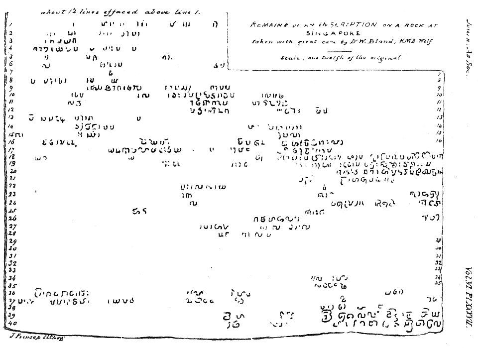
singapore stone
james prinsep
18th-century maps of the strait of magellan
1700s maps of argentina
17th-century maps of the strait of magellan
maps in the rijksmuseum amsterdam
17th-century maps of the strait of magellan
maps by nicolas sanson
101 - 200 of 299
Next page
/ 3


![Bosphorus Cimmerius et regnum bosphoranum / ex collectionibus... Gulielmi Sanson... Mille passus 30 [= 0m.064]; stadia 200, 1665](https://cdn.creazilla.com/illustrations/10001442695/bosphorus-cimmerius-et-regnum-bosphoranum-ex-collectionibus-gulielmi-sanson-mille-passus-30-0m-064-stadia-200-1665-md.jpg)

![Bosphorus Cimmerius et regnum bosphoranum / ex colectionibus... Gulielmi Sanson... Mille passus [= 0m.064]; studia 200, 1665](https://cdn.creazilla.com/illustrations/10001580087/bosphorus-cimmerius-et-regnum-bosphoranum-ex-colectionibus-gulielmi-sanson-mille-passus-0m064-studia-200-1665-md.jpg)
![Anaplus Bosphori Thracii / ex indagationibus Petri Gyllii; delineatus [a] Gulielmo Sanson..., 1665](https://cdn.creazilla.com/illustrations/10001604206/anaplus-bosphori-thracii-ex-indagationibus-petri-gyllii-delineatus-a-gulielmo-sanson-1665-md.jpg)


![Gerardi Mercatoris and I. Hondii Atlas or Representation of the Universal World, and of the Parts of It, Made in Tables and Very Ample Descriptions. [t. 2].](https://cdn.creazilla.com/illustrations/10001243780/gerardi-mercatoris-and-i-hondii-atlas-or-representation-of-the-universal-world-and-of-the-parts-of-it-made-in-tables-and-very-ample-descriptions-t-2-sm.webp)


![Map of Paraguay, Chile, and Strait of Magellan - Guillaume de L'Isle, [1703-1708]](https://cdn.creazilla.com/illustrations/10001534848/map-of-paraguay-chile-and-strait-of-magellan-guillaume-de-lisle-1703-1708-md.jpg)

